
Supervisor:
Giambattista Zaccariotto
A territorial street is associated with the experience and qualities that come with it, including things such as material choices, comfort, and views. The primary design strategy relies on dividing the project into multiple different tracks, using forest lines to separate them from one another. This means that pedestrians and bicyclists will consistently remain both spatially and visually separated from vehicular traffic, making it a more comfortable space for all users.
Context
E39 is one of the busiest highways in Norway. It stretches all the way from Kristiansand in the south to Trondheim in the north, making it the primary route of travel along the Norwegian west coast. At approximately the halfway point it runs through Bergen, the largest and most populous city on the Norwegian west coast. Although E39 functions somewhat successfully throughout the majority of its stretch across the larger Bergen metropolitan area, it becomes particularly problematic once one travels north of the borough of Åsane.
This project focuses its attention upon the stretch of E39 north of Åsane which cuts through Hylkje. This is an extremely problematic stretch of road for a number of reasons. It cuts through a densely populated residential neighborhood, leading to multiple complications and dangerous situations for both vehicles and pedestrians. Given the spatial limitations, the highway is only one lane wide in either direction, leading to heavy congestion during rush hour. In addition, the many driveways and crosswalks contribute to slowing down the traffic even more. Finally, dangerous situations arise from the adjacency of the pavement to the road, as well as the major intersections (which have been the cause of both fatal and near-fatal accidents).

The primary goal of this project is to construct a proposal for transforming the road’s status as a highway, focused primarily on cars and heavy traffic, to a territorial street which reduces heavy traffic and prioritizes pedestrians and bicyclists. To understand what this implies, one must understand the difference between a motorway and a highway, and what a territorial street is. For a road to qualify as a motorway in Norway, there are quite strict restrictions. It must have at least two lanes in either direction and it must not intersect with other, smaller roads (Gisle, 2025). This road clearly does not satisfy these criteria, despite being a primary highway, so it becomes what is referred to in Norwegian as a “motortrafikkvei”, which means that it is still a primary highway, but without the qualities of a typical motorway. In English this can still loosely be referred to as a highway, but on a smaller scale than what is most commonly associated with that status. This is clearly already an indication of why it is so unsuccessful.
The concept of a “territorial street” is largely tied to how Jane Jacobs describes a successful street in the book “The Death and Life of Great American Cities.” This includes topics such as the importance of lighting and how a street is read in conjunction to what surrounds it. Jacobs also describes three qualities which are essential for a successful street: there must be a clear distinction between what is public and what is private, there must be a natural surveillance to keep it safe, and it must be used fairly continuously. (Jacobs, 1961, p. 35-37) What this project describes as a “territorial street” ties back to all of this, and more. A territorial street is associated with the experience and the qualities that come with it. This includes things such as material choices, comfort, and views.
Scenarios
This project works under an important scenario. The project assumes that the Nordhordlands tunnel will have already been built. This tunnel was initially proposed in the 1990s as a replacement for the highway which would return the stretch along Hylkje to being a smaller scale, local street. The tunnel was unfortunately abandoned, and in the subsequent years the highway became busier, with more industry moving to Hylkje and its neighboring districts. Although the tunnel was abandoned over thirty years ago, it is now actively being discussed and has been promised to be built within four years, meaning that this would become a replacement for the existing highway. (Reksnes, 2024).

Working in parallel to the new tunnel, this project subsequently suggests the implementation of using the fjord for heavy traffic. Hylkje has become the new home to multiple large warehouses for the Bergen metropolitan area, including the main warehouses for both Rema 1000 and Nortekstil. This project suggests the use of small electric barges on the fjord to transport local deliveries to hubs located in key areas throughout the city. Finally, small trucks would transport the deliveries for the final stretch, reducing trucks and emissions by a significant amount. This strategy of transporting goods through inland waterways has already been utilized throughout large parts of Europe, for example Paris.

Design Strategy
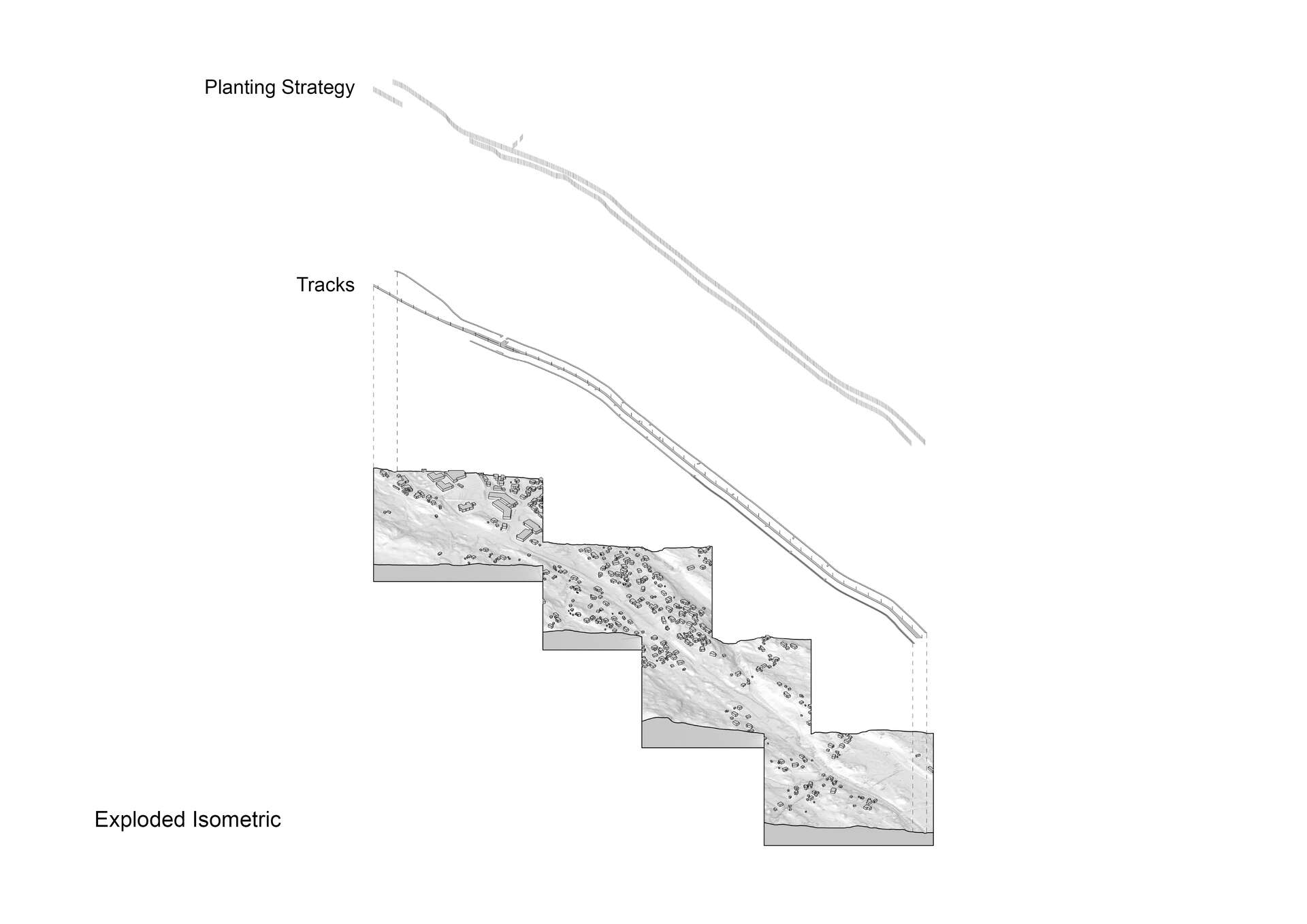
The overall goal of this project is to create a consistent and efficient street for all users, including drivers, bicyclists, and pedestrians. By developing continuity throughout the project and creating a language which remains consistent and adaptable throughout the project, one is able to make it feel less fragmented than it is today. The primary design strategy relies on dividing the project into multiple different tracks, using forest lines to separate them from one another. This means that the pedestrians and bicyclists will consistently remain both spatially and visually separated from the vehicular traffic, creating a more comfortable space for all users.
The project is divided into four distinctive regions which are determined by both their topographical and built conditions. “The Forest” is distinctive for its consistently heavy spruce forest which lines the majority of the eastern side of the road. “The Small Canyon” and “The Grand Canyon” are both distinctive for their canyon-like topography, making them significantly spatially limited. Finally, “The Residential Neighborhood” is distinctive for its consistent downward slope towards the Northeast, as well as its dense residential neighborhood. By dividing the project into these four distinctive districts, one is able to understand how to approach all of the unique conditions and challenges which the site offers today, thus being able to create a language which can be used beyond only this brief stretch of road.

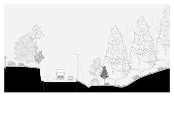
The project is primarily designed and illustrated through sections. Throughout the entire project (apart from the very Northernmost portion) the design follows the same pattern, namely: WALK | BIKE | DRIVE | BIKE | WALK. Although the left and right pedestrian and bike paths serve the same purpose, they have unique designs and experiences. While the left side is a more traditional paved sidewalk, the right side is an elevated wooden walkway. The right side consistently has more space to work with, denser vegetation, and greater topographical inconsistencies than the left side. Because of these conditions it is designed more as a nature trail, while remaining equally practical and serving the same overall purpose as the left side.
All Sections Showed in Sequence: Existing Section → Designed Section




The project utilizes primarily birch (Betula Pubescens) and pine (Pinus Sylvestris) to create a sense of transparency throughout the project, while the lower vegetation, which utilizes typical native Norwegian shrubs (including Frangula Alnus, Rhamnus Cathartica, and Viburnum Opulus) brings a sense of privacy between the different tracks. This way pedestrians and bicyclists do not feel claustrophobic within their respective tracks, while still feeling separated and protected from the cars. The trees are planted in a loose grid pattern, with the intention that over time the grid will become less apparent. With the growth of the lower vegetation as well, it will over time appear more wild and less orderly, while still being controlled to benefit the experience of all users.

Referances
Solvoll, Gisle. “Motorvei,” 2025. https://snl.no/motorvei.
Jacobs, Jane. The Death and Life of Great American Cities. 1961.
Reksnes, Asgeir, et al. “Bergen får ny innfartsåre frå nord - regjeringa lovar milliardveg i Nasjonal transportplan.” 2024. https://www.nrk.no/vestland/lovar-nordhordlandstunnelen-innan-fa-ar-i-nasjonal-transportplan-1.16807514.
Tilførselsveg til Salhusbrua Langamyrane – Klauvaneset: Tegninger for skjønn. Statens Vegvesen, 1990.
"Inland waterway transport aids deliveries in Paris for Ikea and Franprix." 2024. https://green-inland-ports.eu/inland-waterway-transport-aids-deliveries-in-paris-for-ikea-and-franprix/.
In Sequence: Renders, Model Photography, Exploded Isometric, Plans, Diagram





Contact

Jonathan Hordvik Alvarez holds a Bachelor of Science in Architecture from the University of Illinois at Chicago. Upon completion of his degree he completed an International Master of Landscape Architecture at the Oslo School of Architecture and Design. This diploma project was nominated for the award "Excellence in Spatial Layout." During his time at AHO he also did work for Espen Vatn from Vatn Architecture, as well as doing work for David Brown during his time at UIC.