
Supervisor:
Halvor Weider Ellefsen
Introduction
Urban development in Oslo has repeatedly shown how large-scale infrastructure, when addressed too late in the planning process, can create lasting spatial barriers. Roads and railways designed primarily for efficiency often weaken soft connections, fragment neighbourhoods, and limit access to landscapes that could otherwise support urban life. This project explores how gray infrastructure can instead be treated as a formative spatial element, one that actively shapes movement, public space, and long-term urban development.

Site and infrastructure
The project focuses on Breivoll, a former industrial area in the Alna valley shaped by heavy rail logistics, freight operations, and large-scale infrastructure. Despite its central position in eastern Oslo and its proximity to primeval forest and a meandering river, the area remains fragmented and poorly connected to its surroundings.
Through mapping and infrastructural analysis, Breivoll is identified as a site where the railway plays a defining role in shaping both land use and movement. Rather than working around this condition, the project engages directly with the technical constraints of the rail system, including freight traffic, grade limitations, and fixed crossing points, and treats them as design drivers.
Rail Structure and Spatial Strategy
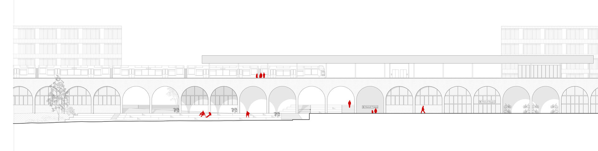
The proposal introduces a new transport hub at Breivoll, combining a train station and a metro station, and reorganises the rail alignment through an elevated structure inspired by historical viaducts. By lifting the tracks, movement and public space are allowed to pass beneath while maintaining operational requirements above. The intention is not to remove the railway as a barrier, but to redefine it by reducing its functional and perceptual impact and establishing continuity at ground level.

Urban Framework
Urban life is organised around this infrastructural framework. Public functions and pedestrian routes are placed along the viaduct, forming a continuous connection between the urban context to the west and the Alna miljøpark to the east. A phased development strategy outlines how accessibility, housing, and public space can be introduced gradually over time, allowing infrastructure to support long-term transformation rather than constrain it.

The project is presented as a design-driven investigation grounded in real technical conditions. Its contribution lies in demonstrating how early and deliberate engagement with rail infrastructure can support coherent urban development and allow infrastructure to function as an integrated part of the city.




Contact

Erlend Aastorp Vatne / Erlend.vat@gmail.com / +47 41222608